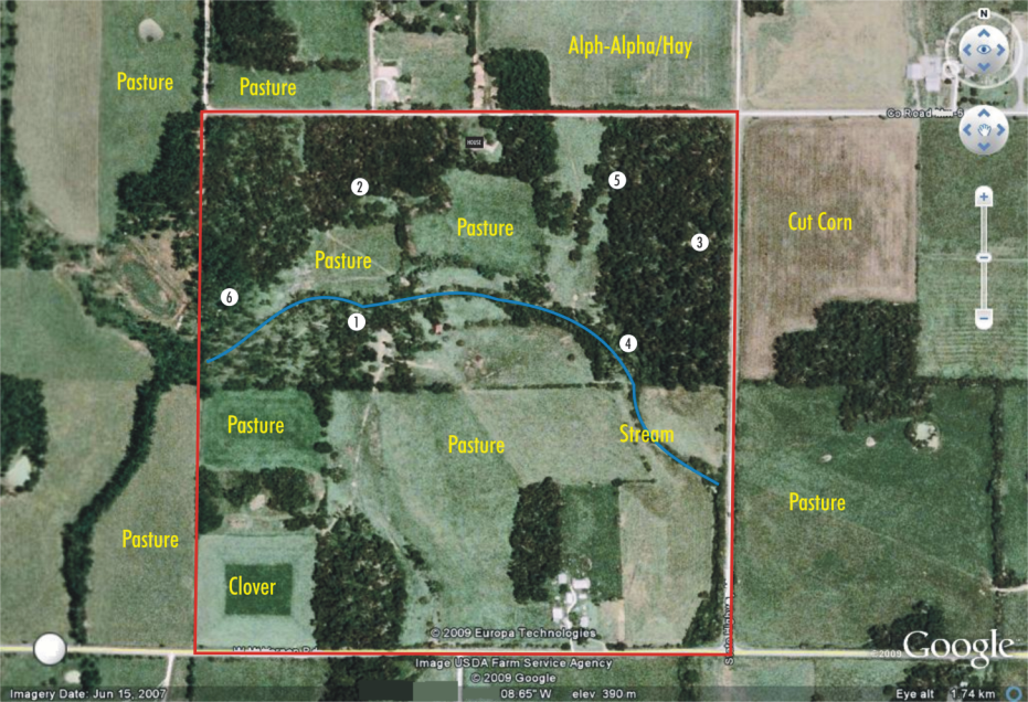
Where Would You Hunt? (If you had to pick one ;-)
Below I’m attaching a google earth image of a property that I hunt with numbers signifying stand sites. I thought it would be fun to have a little survey on where you all would hunt just from looking at the pic! I know there’s a lot more info that would be helpful in determining that, but I thought this would be fun anyway! You can just comment on this post and pick one of the stand #’s. We’ll see which spot the majority of you would at least start at!!

I’ve been wanting to write this for some time now, just hadn’t had the chance til now. Ever wondered why deer seemed to like a certain area? Ever wondered what was over on the neighboring property? Ever wonder where the natural funnels are on a newly acquired piece of ground? Well, your wondering is over! The answer to all those questions can be found while sitting in your living room playing with google earth!
I moved to southwest Missouri a few years ago, so I was starting from scratch on finding private hunting ground. You can drive around, but with gas prices and being unfamiliar with the area, that just didn’t seem extremely practical. So I decided to check out my area from a bird’s eye view. I simply got onto google earth and within no time I had picked 6-7 properties that looked like great deer/turkey habitat. I now have permission to hunt 4 of those properties! I’ll do a separate write up someday on how to be successfull in gaining & keeping permission to hunt.
This is not only a great tool for new properties, but it can greatly enhance your knowledge of a property you’ve hunted for years. There are just certain things you don’t see at ground level. I think the most helpful thing google earth does for you on an older property is give you a great look at the neighboring properties. It can greatly enhance your knowledge of the deer movement in your area.
Last but not least, is that google earth is FREE & FUN! It’s so cool to be able to scout while sitting on your couch! Of course, you’ll want to get your boots on the ground and verify what you’re seeing, but it will cut the wasted scouting time in half!
There are 5 Comments to "Where Would You Hunt? (If you had to pick one ;-)"
Hey man!!! I have been using Google Earth for a while now and it is a very helpful tool for sure. I have repositioned several stands on our property after looking at the “big picture”. How many acres is the outlined property you are showing here. I would like to get an idea of the size of the wooded areas to see if they may be large eough for bedding areas…also I like to see more area than what you show here. Are there any really large areas of timber close by? Good luck hunting to ya’!!!
-Shane
Thanks a lot for checking me out Shane! The outlined area is 160 acres. There aren’t any patches of timber bigger than what you can see for at least 1mi from the property. This is pretty open country, especially for what I’m used to in north Missouri!
Good luck to you as well!
Nathan
i would probably pick stand #1 if there is a north wind. but it’s hard to tell how thick the woods are or what kind of trees are in this spot.
As you know, everything would depend on what time of year it is, and how thick everything is. However, If I was going to go to one just by looking at this picture, it would be stand #4 for sure. Water, food, bedding ground, and timber all close by, plus its at a natural funnel in the pasture along the creek.
Good comment! That’s where the farmer has seen a good buck!